What are marine heatwaves?
Marine heatwaves are periods of unusually high sea surface temperatures (SST) that last for days to months, often extending across large areas of the ocean. In scientific terms, it is defined as a period of at least 5 days with temperatures warmer than the 90th percentile of historic data for that location and time of year. They can vary in duration, intensity, area and depth.
Scientists categorise marine heatwaves based on their intensity as Category 1 = Moderate, Category 2 = Strong, Category 3 = Severe and Category 4 = Extreme.
The first globally recognised marine heatwave occurred during the summer of 2010/11, off the west coast of Western Australia. This extreme event resulted in fish kills, coral bleaching, loss of seagrass and kelp forests, shifted distributions of fish stocks and impacted fisheries such as abalone and rock lobster. This single event launched a brand new research focus in ocean climate extremes.
Government agencies, research institutions, and local communities around the world are working together to better monitor, understand their causes, predict when they will occur, and assess their impacts on marine ecosystems.
Ocean climate outlook for WA’s 2025/26 summer
Seasonal ocean forecasts from CSIRO and the Bureau of Meteorology indicate a high likelihood of patchy, moderate to strong marine heatwave conditions over the remainder of the year.
Ocean temperatures throughout winter and spring 2025 remained well above average across most of Western Australia's waters, which indicates higher‑than‑average subsurface heat.
This means there is potential for warmer‑than‑average ocean conditions, an elevated risk of moderate localised or regional marine heatwave events, and an increased likelihood of localised fish kill events.
How is DPIRD responding?
DPIRD's Aquatic Science and Assessment Climate Change Team routinely monitor ocean conditions and ocean extremes using a combination of satellite, real‑time ocean buoy, coastal modelling and forecast data.
Through this routine monitoring, early detection of extreme warming events helps guide proactive management.
When a significant event is identified, the DPIRD marine heatwave response team formally convenes to assess and communicate event briefings.
DPIRD has developed a Marine Heatwave Response Plan for Western Australia's Wild Capture Fisheries and Aquaculture, which outlines DPIRD's approach for identifying and responding to a marine heatwave affecting wild‑catch fisheries (commercial, recreational, charter and customary) and aquaculture resources within WA's waters.
It provides risk‑reduction strategies and establishes best‑practice processes for each stage of the hazard management and response phases. The plan operates in conjunction with WA's existing aquatic resource management framework, including relevant legislation, subsidiary legislation and policies.
Feedback can be provided to marineheatwaves@dpird.wa.gov.au.
DPIRD works with other agencies, universities and stakeholder groups to better understand the drivers of marine heatwaves and their impacts.
Ocean Decade Project – Advancing predictions of Western Australian marine heatwaves and impacts on marine ecosystems
Downscaled regional climate models for WA coastal regions are currently underway as part of an external project which also provides preliminary marine heatwave forecast information for selected regions.Sea Change Australia
DPIRD scientists are working with the Sea Change Australia research team at the University of Tasmania, Institute for Marine and Antarctic Studies, CSIRO and Centre for Marine Socioecology, as well as industry representatives, to learn how to best share climate information and build the seafood sector’s ability to adapt.Developing management strategies (e.g. adjusting fisheries quotas or protecting key habitats) to reduce the risks posed by marine heatwaves.
Providing resources to fishers, aquaculturists, and coastal communities on how to identify, report, and mitigate heatwave impacts.
Additionally, when a marine heatwave occurs, DPIRD releases a Marine heatwave conditions in WA marine waters Update which includes:
- information relevant to each bioregion
- forecasts
- actions for fishers and aquaculture operators to undertake
- observed impacts
- reporting and support links
- future updates.
Subscribe to the Marine heatwave conditions in WA marine waters Update.
Marine heatwave updates
Subscribe to receive information during a marine heatwave event which includes information relevant to each bioregion, forecasts, actions for fishers and aquaculture operators to undertake and observed impacts.
SubscribeClimate projections of marine heatwaves
Previous heatwave events
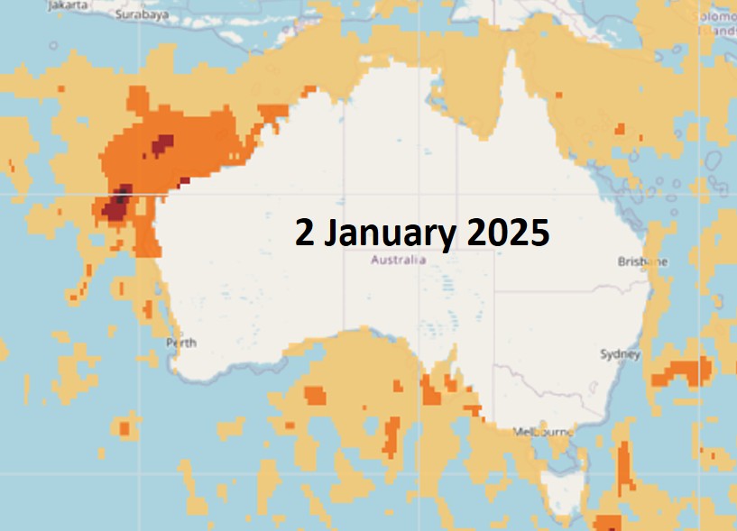
The 2024–25 WA marine heatwave first developed across the North‑West Shelf region during September 2024 as a moderate event and reached severe intensity at its peak during early January 2025.
Nearshore waters along the Pilbara coast experienced the greatest SST anomalies of 4–5 degrees and SST ranges between 31–32 degrees. Once the peak monsoon activity arrived in late January, a series of tropical cyclone activities helped cool the surface waters across the north‑west shelf region and dissipate marine heatwave conditions.
The event then extended southward into the Gascoyne bioregion during mid‑January, creating strong marine heatwave conditions with the Ningaloo and Exmouth Gulf regions experiencing record‑level SSTs. Aided by a surge in the Leeuwin Current, strong heatwave conditions reached the west and south coasts of WA during February and March 2025, and these conditions persisted until June 2025 when the marine heatwave finally abated.
Western Australian fisheries bioregions experienced almost 300 marine heatwave days between September 2024 and July 2025, making this the longest and largest event observed for WA.
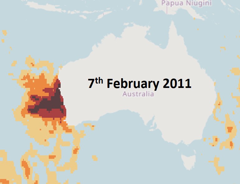
The 2011 marine heatwave event raised nearshore water temperatures along the Gascoyne and mid‑west coast of Western Australia to 2–3°C higher than mean historical levels and within Shark Bay the temperatures even exceeded 5°C above average for brief periods.
Classified as an extreme category event, it lasted between October 2010 and March 2011 and occurred when the Leeuwin Current strengthened over the summer months, transporting very warm waters from the Gascoyne to the South Coast.
The immediate and short‑term effects on the marine biota were devastating, with massive mortality of fish and invertebrate species in some areas, range extensions of some tropical species with sightings well south of their normal ranges, coral bleaching events, phytoplankton blooms and significant loss of seagrass habitats in some regions.