Options to assess on-farm salinity
Dryland salinity can be assessed by observation or measurement. Observation can indicate salinity levels but is not always reliable. Direct measurement is more reliable and better for directing management.
The department recommends that dryland salinity management is part of a whole farm, and preferably a whole catchment, water management plan.
Observing salinity
Observation is a fast, cheap way of assessing saline areas, but does not provide the level of information needed to choose management options. We recommend that you use direct measurements wherever large or expensive management is considered.
Landscape position – saline areas are more likely when:
- the site is on a valley floor or change of slope
- the site is above a known hydrological barrier (bedrock highs or dolerite dykes)
- there are other saline areas in similar landscape positions nearby.
Indicators of saline areas include:
- reduction in crop yields and plant growth
- loss of salt sensitive plants and an increase in salt tolerant plants
- Clover reduces or disappears
- An increase in Cotula, sea barley grass, iceplant and samphire
- saline areas are more water-logged and stay wetter longer
- bare patches appear, leaving a white crust on the surface in summer.
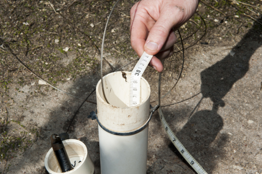
Measuring soil salinity
We recommend using one or more of the measures below to guide expensive management options.
The two most common measures are electrical conductivity of soil samples – in the field or in a laboratory – or using an electromagnetic induction meter (EM) to 'map' salinity across the paddock (e.g. the EM38 or EM31). An EM map is particularly valuable to show variation of salinity across a site.
Measuring electrical conductivity
- field measurement of a soil:water mix electrical conductivity (EC1:5), using a hand-held electrical conductivity meter
- laboratory measurement of soil electrical conductivity, using an electrical conductivity meter
- field measurement of electromagnetic (EM) induction conductivity, using an EM device
- remote sensing using an EM device
Measuring salt content or risk
- groundwater salinity: depth to water table, water salt content, and water table trend
- laboratory measurement of total dissolved solids (TDS)
See measuring soil salinity for more detail.
Groundwater salinity and trends
Estimate risk of changing salinity by measuring depth to the water table, salinity of groundwater, and any trend in depth over at least 5 years. A shallow, rising water table is a high risk. Consult a specialist to interpret measurements.
Waterlogging and salinity
Waterlogging increases the susceptibility of plants to salt damage by increasing salt uptake.
We recommend diagnosing waterlogging and managing susceptibility to waterlogging or choosing plants tolerant of both waterlogging and salinity. Assess the level of waterlogging using information below.
Surface water management can reduce waterlogging and increase production on salt land.
Salinity classes and descriptions
The salinity classes in Table 1 have a description of the land condition and likely plant indicators.
For conversion to other units in this table, see measuring soil salinity.
Table 1: Salinity classes according to the estimated electrical conductivity of a saturated soil extract (ECe), and land and plant condition description.
|
Salinity Class |
Electrical conductivity of soil extract ECe (mS/m) |
Land and plant condition |
|
Non-saline |
<200 |
Land not affected |
|
Slightly saline |
200-400 |
Ground surface is seasonally damp after extended periods of rain; there is a gradual change in pasture composition with reduced vegetation diversity and reduced growth and/or yield of crops and pastures often associated with a slight yellowing of the leaves; sensitive deep rooted species and salt sensitive legumes have reduced production (e.g. white and subclover, soybeans, chickpea); patches of salt tolerant species develop, |
|
Moderately saline |
400-800 |
Ground surface is damp for long periods after extended periods of rain; many field crops and pasture species have severely reduced growth; there is a change in pasture composition to dominance by salt-tolerant species, including grasses; there is reduced vigour of less tolerant species such as strawberry clover; there is dieback in most trees; intermittent streams evolve to permanent streams; there is noticeable rising damp in buildings and some deterioration of roads. |
|
Highly saline |
800-1600 |
Ground surface is waterlogged or permanently moist and too salty for most field crops or lucerne. Halophytes are common; salt tolerant species (e.g. sea barley grass) may dominate large areas and only salt tolerant plants remain unaffected; trees are dead or dying; areas of bare soil have salt crusts; soil structure collapses with subsequent erosion; rising damp and salt efflorescence in buildings is common; there is major deterioration and crumbling of roads. |
|
Severely saline |
1600-3200 |
Halophytes dominate and only highly salt tolerant plants survive (e.g. . There is decreased growth of most halophytes, some may show reddening of leaves and at the upper end of the range even highly salt tolerant species may be scattered and in poor condition. Most trees are dead, except for highly salt tolerant (e.g. Melaleuca spp.). Extensive bare areas have salt stains and/or crystals evident (on some soils a dark organic stain may be visible); topsoil may be flowery or puffy. |
|
Extremely saline |
>3200 |
Bare salt scalds and dominate. Some halophytes die; most have reduced growth. |