The 36 public moorings managed by DPIRD provide shelter from wind and swell in varying weather conditions. To protect the fragile marine benthic habitat and ecosystem of the Abrolhos FHPA, boat-based visitors are encouraged to continue to use public moorings when available.
There is currently no reservation system for public moorings and their availability is on a first come first served basis. Please do not rely on moorings being available.
What to do if no moorings are available
If no moorings are available, anchoring within the FHPA and/or in Reef Observation Areas (ROAs) in a depth of less than 30 m should only occur in locations with soft bottom (that is, sand/mud) using an appropriate anchor, except in circumstances of extreme weather or distress/safety of life at sea, or for the purposes of aiding persons, vessels or aircraft in danger or distress.
Soft bottom is the most effective substrate to reduce the risk of anchor drag. Anchors should be positioned to protect adjacent reef from scouring by anchor chains and ropes across the extent of their entire swing. There are many popular snorkelling and diving locations across the FHPA where sand/mud bottom is located nearby. Weather permitting, visitors are encouraged to anchor vessels of a length of 10 m or more in sand/mud bottom nearby and use a tender to reach points of interest, taking special care to anchor tenders in sand holes.
Public moorings are located within each of the island groups at the Abrolhos.
Mooring locations are provided below (DATUM GDA 94) - north to south.
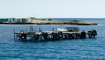
Jetties
The Department of Biodiversity, Conservation and Attractions constructed 2 jetties for public use at East Wallabi and Beacon islands to allow safer access for fishers, commercial tour operators and visitors. Vessels up to 20 m (65 feet) in length can access the East Wallabi Island jetty and smaller vessels, up to 7 m (22 feet) in length can use the Beacon Island jetty.
All other jetties are private property and cannot be used without the written permission of the jetty owner.
| Location | Mooring number | Latitude | Longitude | Depth (metres) |
| Zig Zag Channel | AI - 14 | 28°19.711'S | 113°36.307'E | 12 m |
| Anchorage | AI - 15 | 28°18.481'S | 113°36.354'E | 5 m |
| Northern Island | AI - 46 | 28°18.711'S | 113°36.376'E | 15 m |
| Location | Mooring number | Latitude | Longitude | Depth (metres) |
| Turtle Bay | AI - 1 | 28°25.832'S | 113°44.192'E | 5 m |
| Turtle Bay | AI - 2 | 28°25.870'S | 113°44.241'E | 4 m |
| Turtle Bay | AI - 3 | 28°25.872'S | 113°44.303'E | 4 m |
| Turtle Bay | AI - 4 | 28°25.869'S | 113°44.344'E | 4 m |
| Long Island | AI - 7 | 28°27.593'S | 113°46.277'E | 6 m |
| Long Island | AI - 8 | 28°27.651'S | 113°46.273'E | 5 m |
| Turtle Bay | AI - 12 | 28°25.804'S | 113°44.253'E | 5 m |
| Turtle Bay | AI - 13 | 28°25.810'S | 113°44.310'E | 4.5 m |
| Beacon Island | AI - 16 | 28°28.159'S | 113°47.278'E | 6.5 m |
| Seven Sisters | AI - 39 | 28° 29.769'S | 113° 44.796'E | 11 m |
| Seven Sisters | AI - 40 | 28° 29.638'S | 113° 44.618'E | 12 m |
| West Wallabi Island | AI - 44 | 28° 26.894'S | 113° 41.312'E | 4.8 m |
| West Wallabi Island | AI - 45 | 28° 26.978'S | 113° 41.170'E | 3.6 m |
| Location | Mooring number | Latitude | Longitude | Depth (metres) |
| Sandy Island (South-West) | AI - 9 | 28° 41.947'S | 113° 46.795'E | 14 m |
| White Bank | AI - 10 | 28° 41.987'S | 113° 46.777'E | 14 m |
| Leo Island | AI - 11 | 28°40.932'S | 113°51.695'E | 7 m |
| Sandy Island (West) | AI - 17 | 28° 42.164'S | 113° 46.542'E | 7 m |
| Sandy Island (Second West) | AI - 18 | 28° 42.136'S | 113° 46.607'E | 7 m |
| Morley Island (west) | AI - 19 | 28° 44.646'S | 113° 48.809'E | 4 m |
| Morley Island (East) | AI - 20 | 28° 44.566'S | 113° 48.896'E | 10 m |
| Eagles Nest | AI - 21 | 28°41.553'S | 113°50.086'E | 6.8 m |
| Anemone Lump | AI - 22 | 28°40.288'S | 113°50.611'E | 5 m |
| Roo-Tail Coral | AI - 41 | 28° 42.198'S | 113° 49.765'E | 14 m |
| Leo Island | AI - 42 | 28° 40.864' S | 113° 51.797' E | 18.5 m |
| Morley Island | AI - 43 | 28° 44.511'S | 113° 48.927'E | 17.4 m |
| White Bank | AI - 47 | 28° 41.910'S |
113° 46.545'E |
25 m |
| Location | Mooring number | Latitude | Longitude | Depth (metres) |
| Coral Patches | AI - 23 | 28°51.219'S | 114°0.666'E | 16 m |
| Pelsaert Island | AI - 31 | 28° 58.695'S | 113° 57.177'E | 5.3 m |
| Pelsaert Island | AI - 32 | 28° 58.645'S | 113° 57.161'E | 5 m |
| Pelsaert Island | AI - 33 | 28° 58.594'S | 113° 57.132'E | 3.8 m |
| Pelsaert Island | AI - 34 | 28° 58.527'S | 113° 57.094'E | 3.4 m |
| Pelsaert Island | AI - 35 | 28° 58.002'S | 113° 57.243'E | 13 m |
| Pelsaert Island | AI - 36 | 28° 58.045'S | 113° 57.184'E | 14.8 m |
| Middle Island | AI - 37 | 28° 54.238'S | 113° 54.589'E | 5.3 m |
| Middle Island | AI - 38 | 28° 54.170'S | 113° 54.598'E | 5.7 m |
| Middle Island | AI - 48 | 28° 54.3612'S |
113° 54.2716'E |
15 m |
| Easter Island | AI - 49 | 28° 58.7354'S |
113° 57.2074'E |
15 m |
| Gunn Island | AI - 50 | 28° 53.2604'S |
113° 51.8840'E |
15 m |