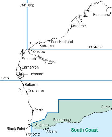
South Coast bioregion
The South Coast bioregion in Western Australia (WA) runs from Black Point east of Augusta (115° 30' east longitude) to the border of WA and South Australia.
Make sure you are familiar with all the rules that apply in the South Coast bioregion before you make your trip. If you are unsure about the rules or need further advice, contact the department.
Areas closed to the take of specific species
The Southern Zone or Zone 3 extends from Busselton Jetty to the South Australian Border, and is open to abalone fishing between 1 October and 15 May the following year.
Closure: The area from Busselton Jetty to Shoal Cape is closed to greenlip abalone fishing until further notice.
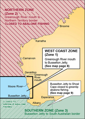
Abalone fishing closures also apply to areas in the North Coast, Gascoyne Coast, and West Coast bioregions.
The marron season is from 12 noon on 8 January to 12 noon on 5 February. Fishing for marron is prohibited at all other times. Marron closures also apply to areas in the West Coast bioregion.
Marron fishing is allowed in the following areas of the South Coast bioregion:
- Deep, Gardner, Warren, Donnelly, Blackwood rivers and their tributaries
Marron fishing is prohibited in the following closed waters in the South Coast bioregion:
- Public water supply dams: any dams not listed on the Water Corporation’s website are generally closed to fishing.
- Shannon River: for marron research purposes, the Shannon River and its tributaries are closed to all fishing.
In some areas in the South Coast bioregion, only snares can be used to fish for marron. Snare-only waters include:
- Big Brook Dam
View the comprehensive list of marron rules on the recreational fishing rules site.
DPIRD manages all fishing and aquaculture inside marine protected areas. Different fishing rules apply in different zones. Ensure you stay up to date with the fishing rules in these areas.
Marine parks in the South Coast bioregion include:
Fishing restrictions apply in the following areas all year-round:
|
Area |
Closure information |
|
Esperance Jetty |
While you may fish from the actual jetty (also known as the Esperance Tank Jetty), fishing is prohibited around what was the original end of the jetty, known locally as ‘the island’. The island is marked with a navigational beacon. |
|
Greens Pool |
Fishing at Greens Pool is prohibited. For more information and GPS coordinates of the closure, view the Prohibition Order. |
|
Shannon River |
Closed to fishing, including all its tributaries and the Shannon Dam, upstream of the intersection of the Shannon River and the natural extension of Springbreak Road (34°52.333' S). |
|
HMAS Perth wreck site |
Closed to fishing within 250 metres of the intersection of 35°04.788' S and 117°58.068' E. |
|
Sanko Harvest wreck site |
closed to fishing within 500 metres of the intersection of 34°07.307' S and 122° 05.03' E. |
Related information
Contact Us
-
DPIRD HillarysOpening hours: 8.30 am to 4.30 pm (Monday to Friday)39 Northside Drive, Hillarys WA 6025