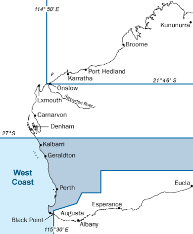
West Coast bioregion
The West Coast bioregion runs from Black Point east of Augusta to the Zuytdorp Cliffs north of Kalbarri (27° S to 115° 30' E).
Make sure you are familiar with all the rules that apply in the West Coast bioregion before you make your trip. If you are unsure about the rules or need further advice, contact a department office near you.
This area includes the Houtman Abrolhos Islands.
Learn more about fishing in the Houtman Abrolhos Islands.Areas closed to the take of specific species
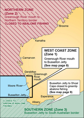
Fishing for abalone north of Greenough River Mouth is prohibited. The area from Busselton Jetty to Shoal Cape is closed to greenlip abalone fishing.
Abalone fishing is divided into 3 zones, and closures apply to each zone.
|
Zone |
Fishing rules |
|
Western Zone (Zone 1): extends from Busselton Jetty to the Greenough River mouth, including all islands. |
Abalone fishing is allowed on the following Saturdays from December 2025 to February 2026 (inclusive) 7 am – 8 am.
|
|
Northern Zone (Zone 2): Greenough River mouth to Northern Territory border. |
The entire Northen Zone, including the area north of Moore River, is closed to abalone fishing until further notice. Sea urchin fishing is permitted in Zone 2 between 1 October and 15 May the following year. |
|
Southern Zone (Zone 3): extends from Busselton Jetty to the South Australian Border. |
The zone is open to abalone fishing between 1 October and 15 May the following year. Closure: the area from Busselton Jetty to Shoal Cape is closed to greenlip abalone fishing. |
Taking, landing or possessing baldchin groper is prohibited within the Abrolhos Islands fish habitat protection area from 1 October to 31 December (inclusive).
Baldchin groper aggregate (group together) in shallow waters in the Abrolhos area to spawn as the water temperature rises.
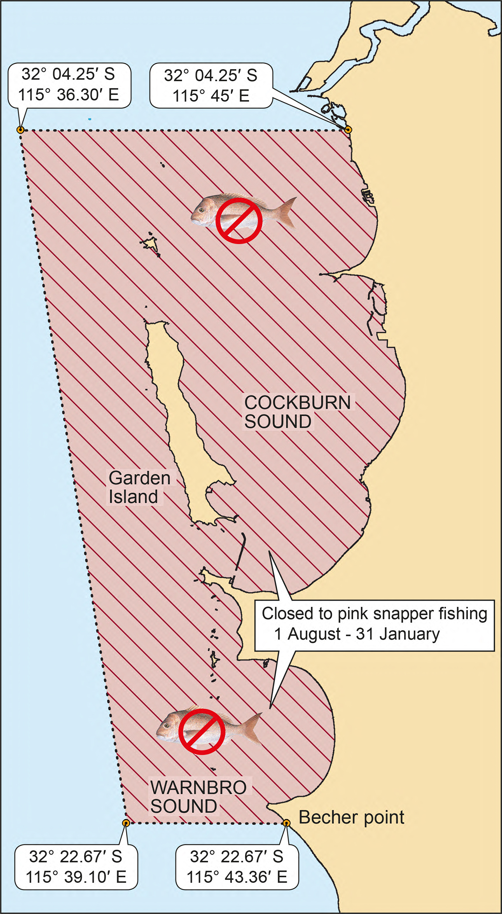
Fishing for pink snapper in Cockburn Sound and Warnbro Sound is closed from 1 August to 31 January (inclusive).
Cockburn Sound is the site of the largest known aggregations (grouping together) of pink snapper in the West Coast bioregion. This seasonal closure is critical for sustaining adequate breeding stocks of these long-lived and slow-growing fish.
It is illegal to fish for or be in possession of pink snapper while line fishing in the closed waters during the closed season.
Line fishing for other species from a boat is allowed, as long as there is no pink snapper on board. Pink snapper taken outside the closed area may be transported through the closure area, as long as no line fishing is undertaken.
Note: The West Coast bioregion demersal closure, which includes pink snapper, also applies. See the dropdown below for more information.
All ray and skate species are protected in Hamelin Bay.
All waters including rivers, estuaries and man-made waterways from the Swan River to Rich Road Minninup Beach (15 km south of Bunbury) are closed to crab fishing from 1 September to 30 November.
The closure protects crab breeding stocks and allows female crabs to spawn before the fishery reopens.

The marron season is from 12 noon on 8 January to 12 noon on 5 February. Fishing for marron is prohibited at all other times. Marron closures also apply to areas in the South Coast bioregion.
Marron fishing is allowed in the following areas of the West Coast bioregion:
- Collie River (upstream of the Australind Bypass Road and downstream of the Wellington Dam wall, and upstream of the Mungalup Road Bridge)
- Donnelly, Blackwood, Capel and Preston rivers and their tributaries
- Moore and Hutt rivers and their tributaries
- Murray River (upstream from the Pinjarra weir).
Marron fishing is prohibited in the following closed waters in the West Coast bioregion:
- Public water supply dams: these dams and their catchment areas are managed by Water Corporation. All fishing is prohibited in these dams and catchments to help keep your drinking water supplies safe. Penalties apply. For details, visit the Water Corporation’s website.
- Margaret River: you must not fish for marron in the Margaret River and its tributaries upstream of the Ten Mile Brook junction (to protect a species known as ‘hairy marron’), or in waters within 300 m upstream and 50 m downstream of the Bussell Highway traffic bridge.
The Water Corporation’s website provides more information on visiting dams.
In some areas in the West Coast bioregion, only snares can be used to fish for marron. Snare-only waters include:
- Margaret River (outside of closures)
- Drakes Brook Dam, Glen Mervyn Dam and Logue Brook Dam
- Harvey Dam and the Harvey River upstream of the South Western Highway including the tributaries flowing into those waters
- Waroona Dam (Lake Navarino) and its tributaries
- Wellington Dam (all waters and tributaries upstream of the Wellington Dam wall, excluding the Collie River upstream of Mungalup Road Bridge).
View the comprehensive list of marron rules on the recreational fishing rules site.
Boat-based recreational fishing for demersal scalefish will remain closed until Spring 2027.
If you catch a demersal scalefish from a boat in the west coast bioregion during the closure, you must return it to the water as soon as possible.
These measures do not apply to land-based recreational fishers, who can continue to fish for demersal scalefish year-round, outside of existing spawning closures.
Note that shore-based spearfishers are not permitted to fish for WA dhufish.
The Yallingup reef Protected Area includes all the waters of the Indian Ocean and reef within a 400 metre radius of the mouth of Yallingup Brook.
In the Yallingup reef Protected Area, you may:
- fish with pointed instruments, rods or handlines for finfish
- catch (using legal fishing gear) squid, cuttlefish, blue swimmer crab and rock lobster. (Note that a licence is required to fish for rock lobster).
All other marine life is protected. This includes, but is not limited to:
- live sea shells (including abalone)
- octopus
- starfish
- sea cucumbers
- rock crabs
- sea urchins
- corals
- algae.
Please note: The Yallingup reef protected area lies within the Ngari Capes Marine Park.
Marine Protected Areas
DPIRD manages all fishing and aquaculture inside marine protected areas. Different fishing rules apply in different zones. Ensure you stay up to date with the fishing rules in these areas.
Fish habitat protection areas (FHPAs)
- Houtman Abrolhos Island fish habitat protection area
- Cottesloe fish habitat protection area
- Kalbarri Blue Holes fish habitat protection area
- Lancelin Island fish habitat protection area.
Marine Park fishing rules information
For specific rules relating to marine protected areas within the West Coast bioregion, visit the Western Australian recreational fishing rules website and search West Coast bioregion.
Recreational fishing rulesFishing restrictions apply in the following areas all year-round:
|
Area |
Closure information |
|
Busselton Jetty Observatory |
Closed to all fishing in the defined area. |
|
Busselton Jetty to Shoal Cape. |
Closed to greenlip abalone fishing. |
|
Cowaramup Bay Reef observation area (Gracetown) |
You may catch finfish, abalone, rock lobster, blue swimmer crabs, cuttlefish and octopus. All other species are protected. |
|
Cowaramup Reef Protected Area |
You may fish with pointed instruments, rods or handlines for finfish and catch (using legal fishing gear) squid, cuttlefish, blue swimmer crab, rock lobster and abalone. Note that a licence is required for rock lobster and abalone. All other marine life is protected. This includes but is not limited to live sea shells, octopus, starfish, rock crabs, sea urchins, corals and algae. Prohibition of the collection of these animals aims to protect the reef and other organisms living on it. |
|
Hamelin Bay |
All ray and skate species are protected in Hamelin Bay. |
|
Heirisson Island (Swan River) |
Lakes on the island downstream of the causeway are closed to all fishing. |
|
Lake Clifton (Mandurah) |
Closed to all fishing. |
|
Yallingup Reef observation area |
All shellfish, reef-top animals, crustaceans, seahorses and sea plants are protected within a 400 metre radius of the mouth of Yallingup Brook. You may only take squid, cuttlefish, rock lobster and blue swimmer crabs in this area. |
|
HMAS Swan wreck site |
Closed to fishing within 200 metres of the intersection of 33°33.06' S and 115°05.947' E. |
|
Lena wreck site |
Closed to fishing within 400 metres of the intersection of 33°20.578' S and 115°33.895' E. |
|
North of Moore River |
Closed to abalone fishing. |
|
Omeo wreck site |
Closed to fishing within the defined site, which commences at 32°06.270' S 115°45.552' E, then following the coastline east to 32°06.360'S and 115°45.740'E, then west to the intersection of 32°06.360' S and 115°45.552'E, then north to the commencement point. |
|
Saxon Ranger wreck site |
Closed to fishing within the defined site, which commences at 32°19.67’ S 115°42.37’ E, then east to the intersection of 115°42.25’ E, then north to the intersection of 32°19.55’ S, then east to the intersection of 115°42.37’ E, then south to the commencement point. |
|
South Tomi wreck site |
Closed to fishing within the defined site, which commences at 28°43.968' S 114°33.392' E, then west to the intersection of 114°33.206' E, then north to the intersection of 28°43.752' S, then east to the intersection of 114°33.392' E, then south to the commencement point. |
Related information
Contact us
-
DPIRD HillarysOpening hours: 8.30 am to 4.30 pm (Monday to Friday)39 Northside Drive, Hillarys WA 6025